Оператор спутниковой связи компания "ТЕСС.КОМ" приобретает б/у оборудование для спутниковой связи ГлобалСтар.
Тел. (095) 775-19-25
office@tecckom.com |
|

|
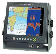
Плоттер + эхолот SamYung SGF 3000
NAVIS 3700
• NAVIS 2500
• Плоттер + эхолот NAVIS 3000
• SGP 3700
• SGP 2500
• Плоттер + эхолот SGF 3000
• SGF 3600 N/A
• SGP 2500 N/A
• Плоттер + эхолот SGF 3000 N/A
FEATURES |
Automatic
tracking system of a partner(connection
with digital SSB and automatic
pilot
system)
|
Built in course
up function for 360?®
revolution, updated electronic
sea chart and simple
one
touch operation |
Can see the display
clearly in anytime and anyplace |
Can input the
depth of the water and the condition
of the bottom, depth detour,
mud line,
wrecks
,obstruction, EEZ ,bottom cable
by electronic sea chart of Samyung
ENC |
Can calculate
actual navigational distance
by coloring according to straight
and curve line
at
voyage |
All functions
can be operated by one touch
and be built data processing
system in high
speed.
|
Compact, slim
and lightweight figure for easy
installation and best portability |
Can input Korean,
English, text, figures in map
and data. |
Data storage
to a built in memory(RAM) or
a floppy diskette |
Clear-view 10.4"
and TFT LCD display |
Can interface
with other navigation device(for
example, autopilot) |
Have printing
function for open-closed valve
to ship for waste |
Can output with
printer and can receive climate
fax |
Built in enlarged
mode for searching shoal of
fishing |
Function for
searching shoal of fish and
function for noise protection
|
Flattening &
enlarging the bottom of the
sea and tracing bottom for clear
discrimination of
fish
in the bottom. |
Controlling &
enlarging the range of depth
at user's discretion |
Automatic output
according to the depth |
Print(option) |
STANDARD(GPS
RECEIVER) |
Receiving frequency
: L1 1574.42 MHz(C/A) |
Number of channels
& tracing satellites : 12
channels 12 satellites |
Receiving type
: Digital 12 channel multi tracking
(Time to first fix is about
21 sec.) |
Accuracy(GPS)??10M 2D RMS(HDOP<2)> |
Accuracy(DGPS)
: Position??3M
2D RMS(HDOP<2)>
Velocity??0.1
KNOT RMS(HDOP<2)> |
DGPS(BEACON),
RECEIVER(DSP-3000LA)
|
Receiving frequency
: 283.5-325.0KHz |
Modulation :
MSK(Minimum Shift Keying) |
Bit rate : 50,100,200bps |
Sensitivity :
10 §?/m
|
STANDARD(PLOTTER) |
Display : color
TFT LCD(10.4") |
Projection :
mercato |
Effective rangeLbelow
85 degrees of latitude |
Scale : 0.25mile~5,000mile(1/2,500~1/37,500,000) |
Marking capacity
and kinds of mark : 10,000 point,
21 kinds |
Tracing capacity
and display color : 20,000 point,
16 color |
Capacity for
user's drawing of shoreline
: 1,000 point(16 color) |
Interface : SAMYUNG,
NMEA0183, FURUNO(CIF), JRC |
Power supply
: DC+16V - +36V, 40W |
Dimensions and
weight : 285(W) X 306(H) X 184(D)
mm, 4kg |
STANDARD(FISH
FINDER) |
Operating frequency
: 50KHz or 200KHz |
Output : 1.5KW |
Display color
: 16 color |
Range of the
depth : 10~1,500M(sea depth,
auto output function),position(shift):1~999 |
Range of bottom : ?? enlargement of
tracing
: 10, 20, 40, 80M
??
enlarging
of flattened bottom : 2.5, 5, 10,
20, 40, 80M |
Automatic output
power control, draft control,
clear noisy etc. |
Basic component |
No. |
Description |
Model |
Q'ty |
Remarks |
1 |
GPS/DGPS
LCD color plotter+ fish
finder |
SGF-3000LA
DSF-3000LA |
1 SET
|
|
2 |
GPS/DGPS
antenna |
SAN-250
DSAN-250 |
1SET |
|
3 |
Transducer |
|
1 SET
|
|
4 |
Remote
controller |
REM-3000F
|
1EA |
|
5 |
Installation
material spare parts, manual |
|
1Lot |
|

|